⚙ Test optionslength, one at a time or all, study mode
Length10 · 25 · all 33✓ Progress saved on this device
Airspace
1. Before a flight, a remote pilot finds a temporary flight restriction (TFR) covering the planned operating area. Which statement is correct?
Why: Section 107.47 requires small UAS operations to comply with the flight restrictions designated by NOTAM under sections 91.137 through 91.145 and 99.7. A TFR applies to drones as much as to manned aircraft, and an airspace authorization does not override it. Check NOTAMs and TFRs before every flight.
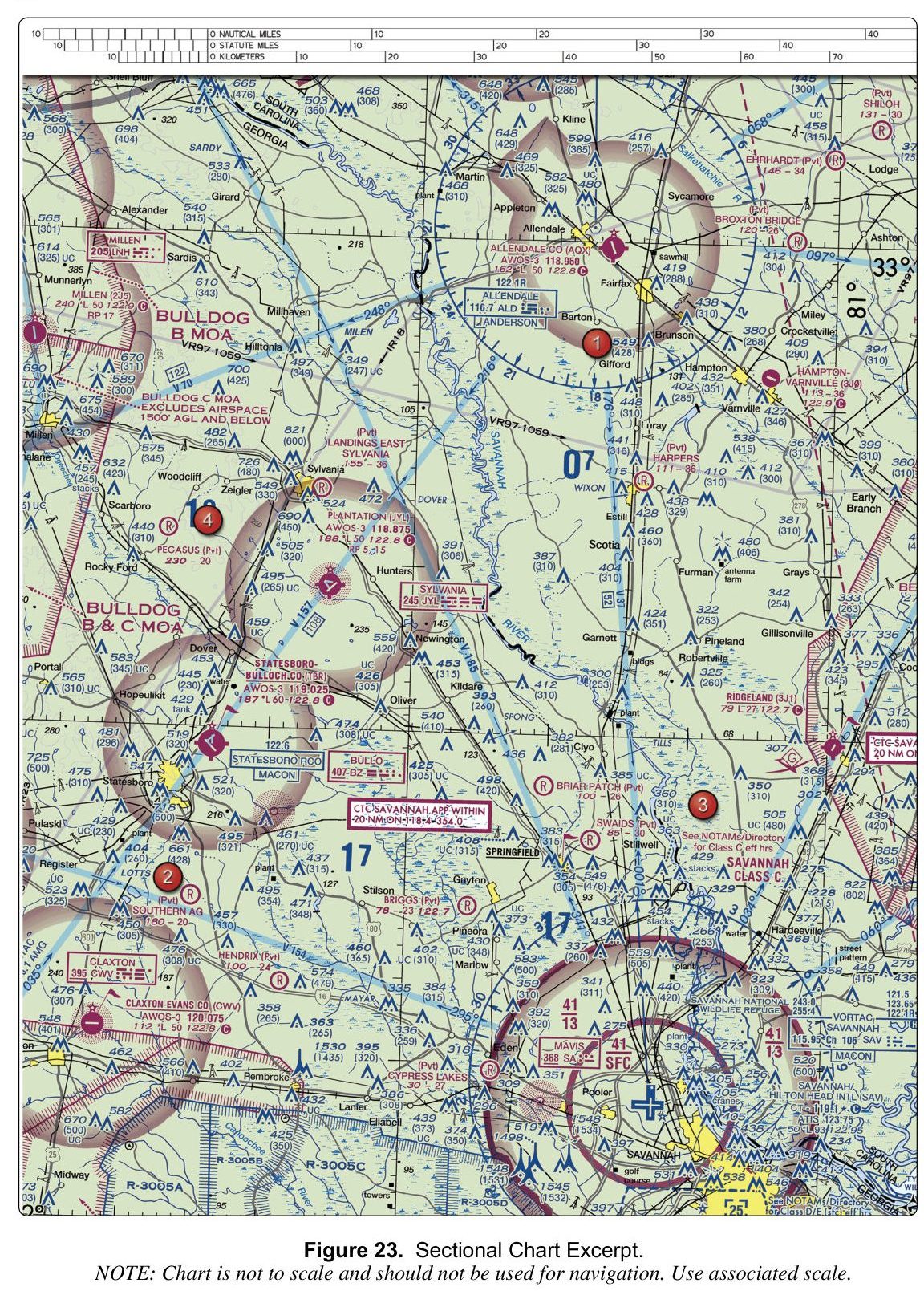
2. (Refer to FAA-CT-8080-2H, Figure 23.) The note printed on the chart for BULLDOG C MOA states that the MOA:
Figure 23 — Sectional chartOpen reference image
From the FAA testing supplement (FAA-CT-8080-2H). Tap the image to open it full size.
Why: On Figure 23, the special-use airspace labeled BULLDOG C MOA carries a printed note that reads 'EXCLUDES AIRSPACE 1500' AGL AND BELOW.' The unit is explicitly AGL, not MSL, so the option stating 1500' MSL is a misread of the unit. The value 1300' does not appear in the note; it may be confused with the 41/13 ceiling-over-floor figure printed on the Savannah Class C airspace nearby.
3. A LAANC request is approved with a ceiling of 300 feet. What does this ceiling value refer to?
Why: LAANC ceilings are expressed in feet above ground level, ranging from 0 to 400 feet, and are never stated in mean sea level. The MSL option is wrong because the LAANC system and the UAS facility map use AGL values exclusively; converting to MSL would require knowing the local terrain elevation, which varies by location and is not how the ceiling is defined. The airport field elevation option is wrong for the same reason: the ceiling is a generic AGL value applied to the ground surface, not a fixed offset from a specific airport elevation. Pilots must account for local terrain when determining the actual MSL altitude at which the 300 ft AGL ceiling is reached.
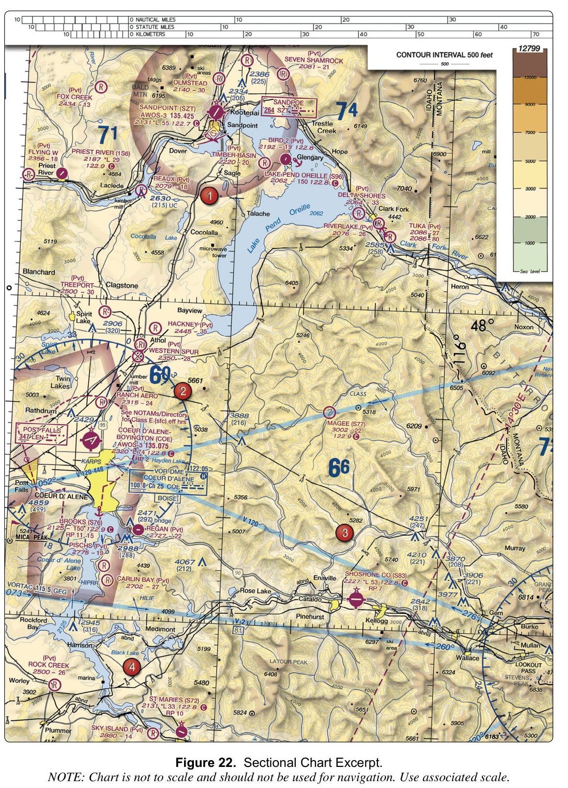
4. (Refer to FAA-CT-8080-2H, Figure 22.) What is the CTAF frequency for Priest River (1S6)?
Figure 22 — Sectional chartOpen reference image
From the FAA testing supplement (FAA-CT-8080-2H). Tap the image to open it full size.
Why: On the chart, the Priest River (1S6) airport entry lists its CTAF as 122.9, printed directly beside the airport identifier. The value 122.8 is the CTAF for several other airports on the same chart (Lake Pend Oreille, Coeur d'Alene-Boyington, Shoshone Co, St Maries), and 122.7 is the CTAF for Sandpoint (SZT). Read the frequency printed next to the 1S6 identifier to confirm 122.9.
5. (Refer to FAA-CT-8080-2H, Figure 23.) The obstacle just east of area 1, near Gifford, has a height of:
Figure 23 — Sectional chartOpen reference image
From the FAA testing supplement (FAA-CT-8080-2H). Tap the image to open it full size.
Why: Next to area 1, beside Gifford, the obstacle is labelled 549 with (428) beneath it. The bold number is the height of the top above mean sea level; the number in parentheses is its height above ground level. So it is 549 feet MSL, or 428 feet above the ground.
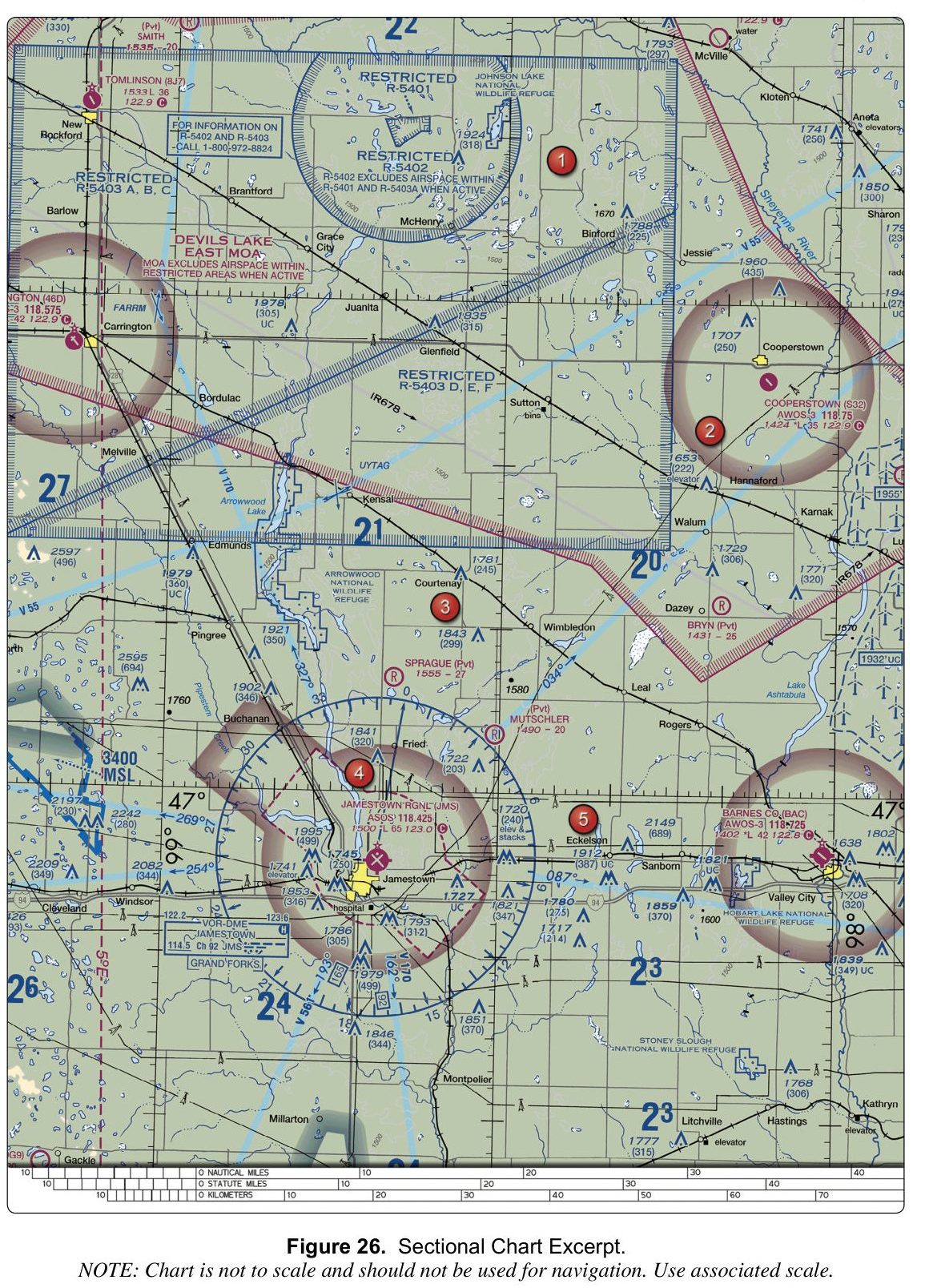
6. (Refer to FAA-CT-8080-2H, Figure 26.) What is the field elevation listed for Barnes Co. (BAC)?
Figure 26 — Sectional chartOpen reference image
From the FAA testing supplement (FAA-CT-8080-2H). Tap the image to open it full size.
Why: On the chart, the Barnes Co. (BAC) airport entry lists the field elevation as 1402 feet. The value 1533 feet is the elevation for Tomlinson (8J7), and 1431 feet is the elevation for Bryn (Pvt). Each airport's elevation is printed directly beside its name in the airport data block.
7. A remote pilot plans to operate a small unmanned aircraft within the lateral boundaries of the Class B airspace core area at a large airport, where the airspace extends from the surface. What must the remote pilot obtain before the flight?
Why: Class B airspace, including its core area that extends from the surface, is controlled airspace. Part 107 requires prior ATC authorization before operating within Class B airspace, typically obtained through LAANC or the FAA's drone zone system. The "waiver" option is incorrect because a waiver is not needed for a standard controlled airspace operation; the pilot simply needs the standard airspace authorization. The "no additional authorization" option is wrong because Class B is controlled airspace and the standard Part 107 operating limits alone do not permit entry without prior authorization.
8. A sectional chart shows a communications tower labeled 2150 (450). The drone will remain within 400 feet horizontally of the tower. Assuming the applicable airspace authorization and all other operating restrictions permit the operation, what is the highest altitude in MSL permitted by the Part 107 structure provision?
Why: The obstacle label shows the top of the tower at 2,150 feet MSL and about 450 feet above the surrounding ground. Under 14 CFR 107.51(b), a small UA may fly higher than 400 feet AGL when it stays within a 400-foot radius of a structure and no more than 400 feet above the structure's immediate uppermost limit: 2,150 + 400 = 2,550 ft MSL. The 2,100 ft option is 400 ft above the ground (1,700 + 400), which ignores the structure provision. The provision does not remove other requirements: in controlled airspace the operation must also comply with the altitude and conditions of the airspace authorization.
9. Which airspace class generally extends from 18,000 feet MSL up to and including flight level 600 over the contiguous United States?
Why: This is the general vertical range of Class A airspace. Class B has individually defined boundaries around busy airports. Class E includes several different types of controlled airspace, including airspace above flight level 600. This airspace-classification question does not authorize a Part 107 drone flight at these altitudes.
10. A Class B airspace shelf on a sectional chart is labeled "100/40". What does this indicate about the vertical extent of that shelf?
Why: Class B and Class C shelf labels give the ceiling over the floor in hundreds of feet MSL: 100/40 means a ceiling of 10,000 ft MSL and a floor of 4,000 ft MSL. Reading the numbers as thousands gives the impossible 10,000-to-40,000 option, and dropping a zero gives 400 to 1,000 ft.