⚙ Test optionslength, one at a time or all, study mode
Length10 · 25 · all 33✓ Progress saved on this device
Airspace
1. Which of the following airspace classes is uncontrolled?
Why: Class G is uncontrolled airspace. Ordinary Part 107 operations there do not require ATC airspace authorization, although ATC may provide certain additional services to aircraft upon request. Class E is controlled airspace; under Part 107, prior ATC authorization is required within the lateral boundaries of a Class E surface area designated for an airport. Class D is also controlled airspace and requires prior authorization for ordinary Part 107 operations. Other flight restrictions can still apply in Class G.
2. The Maximum Elevation Figure in a quadrangle on a sectional chart shows a large "3" followed by a smaller "5." What altitude does this represent?
Why: Maximum Elevation Figures (MEFs) are expressed in thousands and hundreds of feet MSL, so a large 3 followed by a smaller 5 represents 3,500 feet MSL. An MEF is a conservative maximum elevation for the quadrangle based on terrain and vertical obstacles: the FAA applies source-data error allowances and rounds up to the next 100 feet, so it is not simply the exact elevation of the single highest object.
3. A remote pilot is operating at a location whose field elevation is 3,200 ft MSL. The drone's altimeter reads 3,550 ft MSL. What is the drone's altitude above ground level?
Why: Height above ground is the MSL altitude minus the ground elevation: 3,550 - 3,200 = 350 ft AGL. The other options come from subtracting the wrong elevation (3,000 or 3,400 ft) instead of the actual field elevation.
4. What is the typical vertical extent of Class C airspace?
Why: Class C airspace normally extends from the surface to 4,000 feet above the airport elevation, charted in MSL. The 2,500-foot figure belongs to Class D, the airspace around smaller airports with an operating control tower. Surface to 10,000 feet MSL is the typical shape of Class B, around the busiest airports. Each Class C area's actual dimensions are shown on the sectional chart.
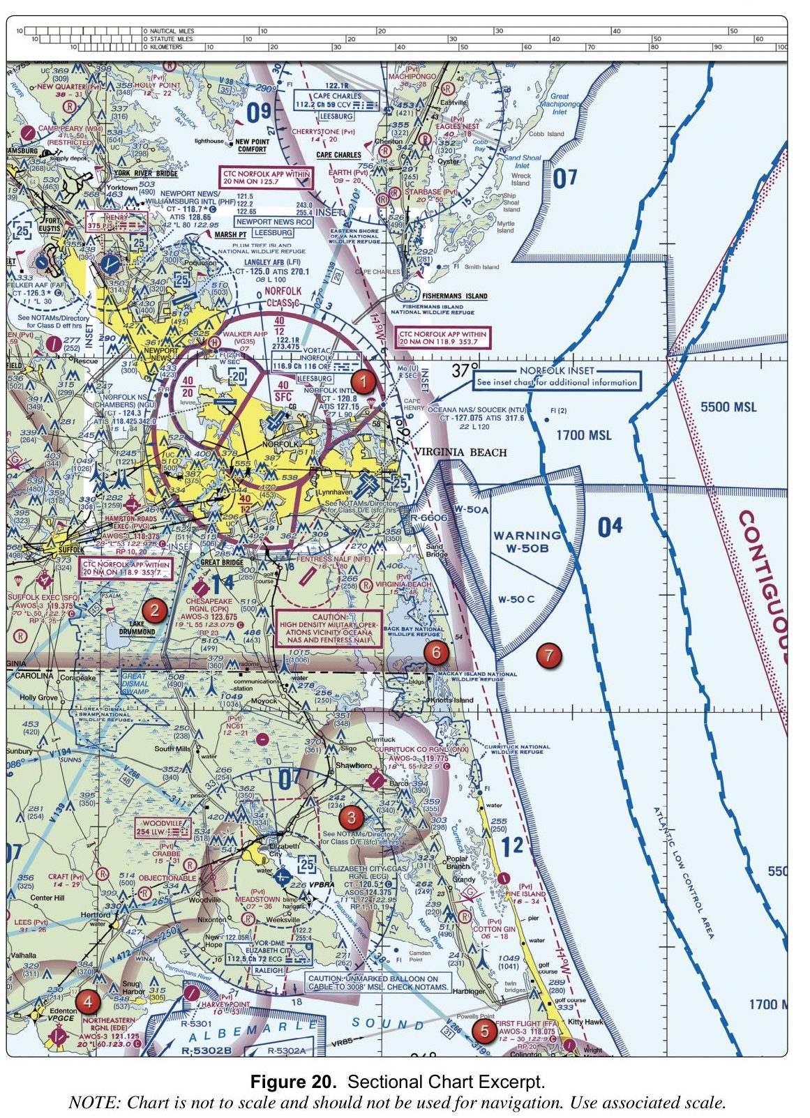
5. (Refer to FAA-CT-8080-2H, Figure 20.) The data block for Langley AFB (LFI) shows a longest runway of 100. How long is the runway?
Figure 20 — Sectional chartOpen reference image
From the FAA testing supplement (FAA-CT-8080-2H). Tap the image to open it full size.
Why: Runway lengths in an airport data block are printed in hundreds of feet, so 100 means 10,000 feet. The 12,000-foot figure belongs to Oceana NAS (NTU), printed as 120, and the 6,000-foot figure to Northeastern Regional (EDE), printed as 60.
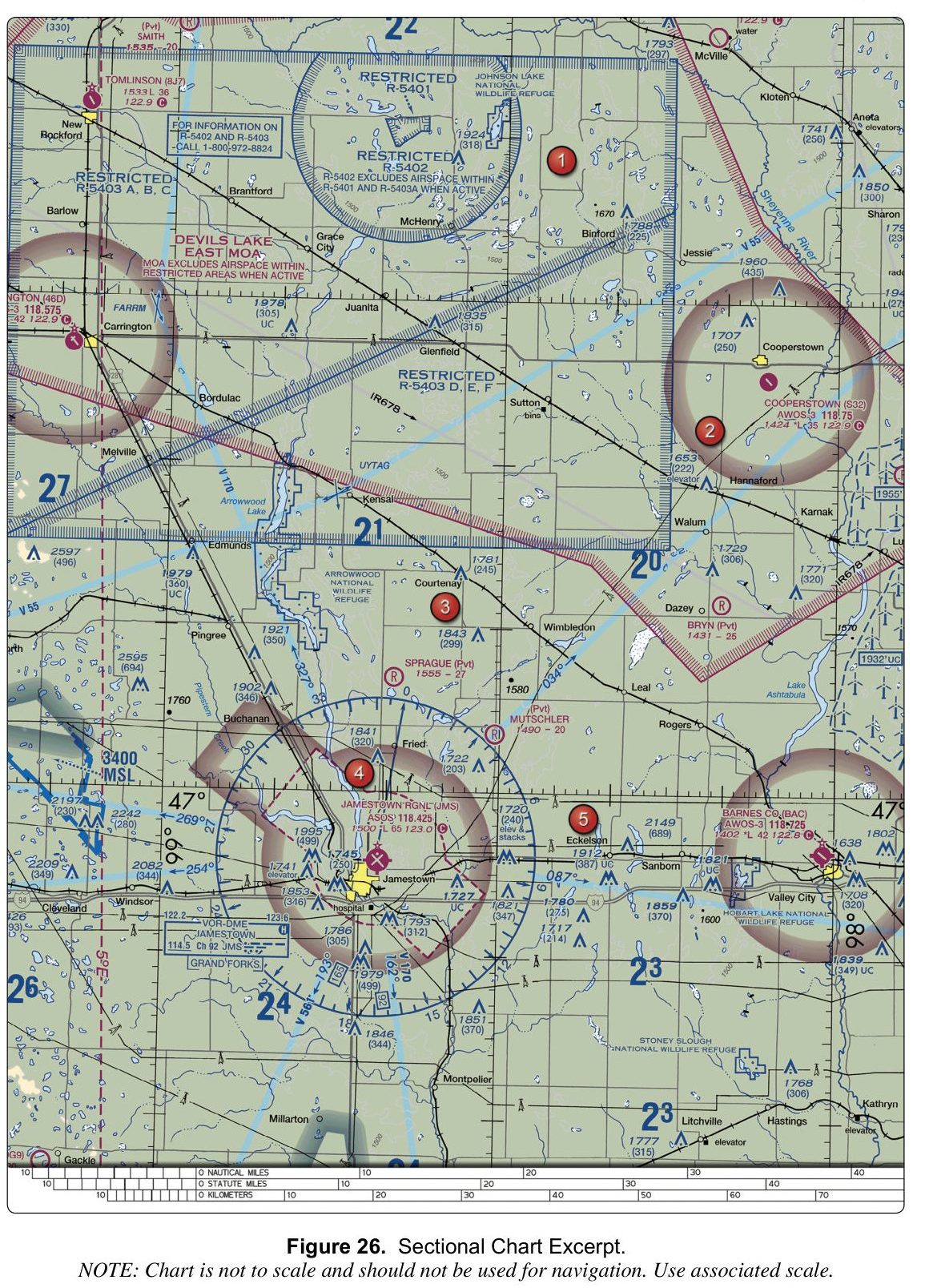
6. (Refer to FAA-CT-8080-2H, Figure 26.) What is the field elevation listed for Barnes Co. (BAC)?
Figure 26 — Sectional chartOpen reference image
From the FAA testing supplement (FAA-CT-8080-2H). Tap the image to open it full size.
Why: On the chart, the Barnes Co. (BAC) airport entry lists the field elevation as 1402 feet. The value 1533 feet is the elevation for Tomlinson (8J7), and 1431 feet is the elevation for Bryn (Pvt). Each airport's elevation is printed directly beside its name in the airport data block.
7. An airport data block on a sectional chart shows *L. What does this indicate about airport lighting?
Why: On a sectional chart, L indicates lighting is in operation from sunset to sunrise. An asterisk before the L (*L) means lighting limitations exist, and the pilot should consult the Chart Supplement for the specific limitation. The symbol does not identify the lighting as high-intensity, and it does not mean there is no lighting.
8. Class D airspace typically extends from the surface up to about what height above the airport?
Why: Class D is usually a cylinder about 2,500 feet above the airport elevation, charted in MSL and rounded, with the exact figure on the sectional. 10,000 feet MSL is the typical top of Class B. Always read the chart for the airport you are flying near.
9. Which airspace class generally extends from 18,000 feet MSL up to and including flight level 600 over the contiguous United States?
Why: This is the general vertical range of Class A airspace. Class B has individually defined boundaries around busy airports. Class E includes several different types of controlled airspace, including airspace above flight level 600. This airspace-classification question does not authorize a Part 107 drone flight at these altitudes.
10. A remote pilot plans to operate a small unmanned aircraft within the lateral boundaries of the Class B airspace core area at a large airport, where the airspace extends from the surface. What must the remote pilot obtain before the flight?
Why: Class B airspace, including its core area that extends from the surface, is controlled airspace. Part 107 requires prior ATC authorization before operating within Class B airspace, typically obtained through LAANC or the FAA's drone zone system. The "waiver" option is incorrect because a waiver is not needed for a standard controlled airspace operation; the pilot simply needs the standard airspace authorization. The "no additional authorization" option is wrong because Class B is controlled airspace and the standard Part 107 operating limits alone do not permit entry without prior authorization.
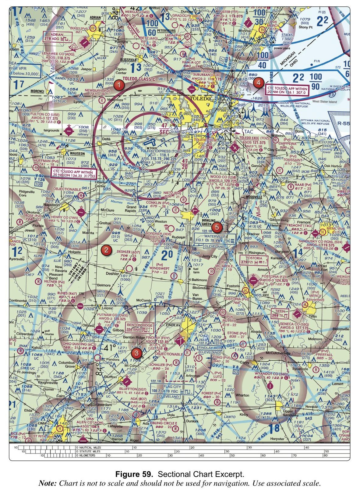
11. (Refer to FAA-CT-8080-2H, Figure 59.) What is the tower frequency for Toledo Express Airport (TOL)?
Figure 59 — Sectional chartOpen reference image
From the FAA testing supplement (FAA-CT-8080-2H). Tap the image to open it full size.
Why: In the Toledo Express (TOL) data block, 'CT - 118.1' is the control tower frequency. 118.75 is the ATIS frequency printed after it, and 118.375 is the ASOS frequency at Lenawee Co (ADG), a different airport on the chart.
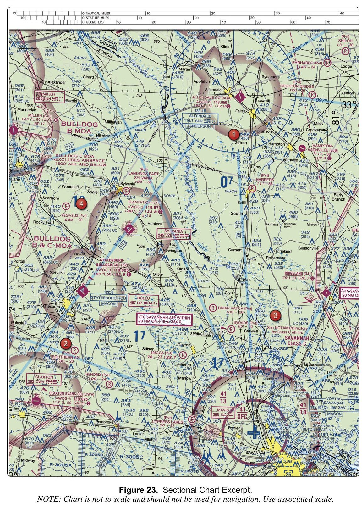
12. (Refer to FAA-CT-8080-2H, Figure 23.) The note printed on the chart for BULLDOG C MOA states that the MOA:
Figure 23 — Sectional chartOpen reference image
From the FAA testing supplement (FAA-CT-8080-2H). Tap the image to open it full size.
Why: On Figure 23, the special-use airspace labeled BULLDOG C MOA carries a printed note that reads 'EXCLUDES AIRSPACE 1500' AGL AND BELOW.' The unit is explicitly AGL, not MSL, so the option stating 1500' MSL is a misread of the unit. The value 1300' does not appear in the note; it may be confused with the 41/13 ceiling-over-floor figure printed on the Savannah Class C airspace nearby.
13. A LAANC request is approved with a ceiling of 300 feet. What does this ceiling value refer to?
Why: LAANC ceilings are expressed in feet above ground level, ranging from 0 to 400 feet, and are never stated in mean sea level. The MSL option is wrong because the LAANC system and the UAS facility map use AGL values exclusively; converting to MSL would require knowing the local terrain elevation, which varies by location and is not how the ceiling is defined. The airport field elevation option is wrong for the same reason: the ceiling is a generic AGL value applied to the ground surface, not a fixed offset from a specific airport elevation. Pilots must account for local terrain when determining the actual MSL altitude at which the 300 ft AGL ceiling is reached.
14. (Refer to FAA-CT-8080-2H, Figure 23.) The obstacle just east of area 1, near Gifford, has a height of:
Figure 23 — Sectional chartOpen reference image
From the FAA testing supplement (FAA-CT-8080-2H). Tap the image to open it full size.
Why: Next to area 1, beside Gifford, the obstacle is labelled 549 with (428) beneath it. The bold number is the height of the top above mean sea level; the number in parentheses is its height above ground level. So it is 549 feet MSL, or 428 feet above the ground.
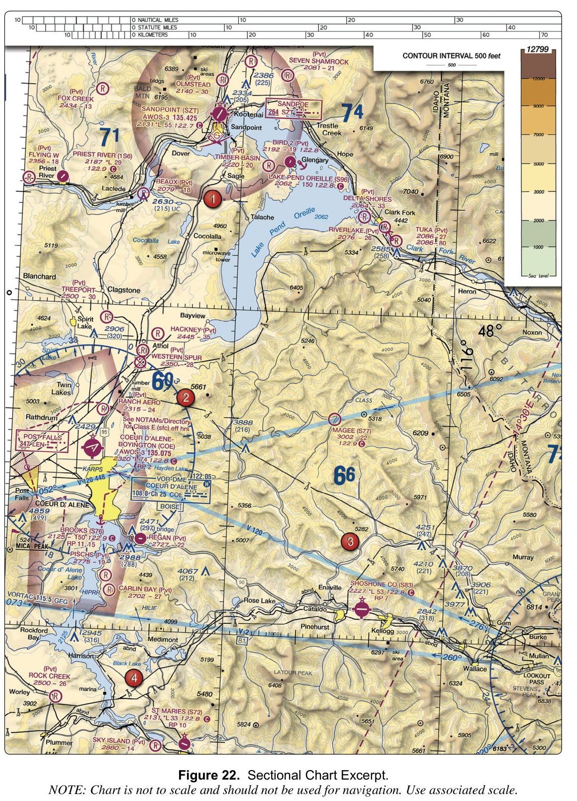
15. (Refer to FAA-CT-8080-2H, Figure 22.) The data block for Lake Pend Oreille (S96) shows a longest runway of 150. How long is the landing area?
Figure 22 — Sectional chartOpen reference image
From the FAA testing supplement (FAA-CT-8080-2H). Tap the image to open it full size.
Why: Lengths in a data block are printed in hundreds of feet, so 150 means 15,000 feet, not 1,500. The 5,300-foot figure belongs to Shoshone County (S83), printed as 53.
16. A Class B airspace shelf on a sectional chart is labeled "100/40". What does this indicate about the vertical extent of that shelf?
Why: Class B and Class C shelf labels give the ceiling over the floor in hundreds of feet MSL: 100/40 means a ceiling of 10,000 ft MSL and a floor of 4,000 ft MSL. Reading the numbers as thousands gives the impossible 10,000-to-40,000 option, and dropping a zero gives 400 to 1,000 ft.
17. (Refer to FAA-CT-8080-2H, Figure 20.) What is the tower frequency for Newport News/Williamsburg International (PHF)?
Figure 20 — Sectional chartOpen reference image
From the FAA testing supplement (FAA-CT-8080-2H). Tap the image to open it full size.
Why: In the airport data block for Newport News/Williamsburg Intl (PHF), 'CT - 118.7' is the control tower frequency. 128.65 is the ATIS frequency printed on the line below it, and 118.425 is the ATIS frequency for Norfolk NS (Chambers), a different airport on the chart.
18. Class B airspace around a large airport typically extends from the surface up to what altitude?
Why: Class B airspace typically tops out around 10,000 feet MSL, but the real figure is printed on the sectional chart for each airport and varies. 2,500 feet above the airport is the usual top of Class D, and 12,500 feet is not a standard airspace boundary. For a drone flight, read the chart rather than relying on a typical value.
19. (Refer to FAA-CT-8080-2H, Figure 22.) What is the field elevation of Magee (S77)?
Figure 22 — Sectional chartOpen reference image
From the FAA testing supplement (FAA-CT-8080-2H). Tap the image to open it full size.
Why: On the chart, the Magee (S77) airport entry prints an elevation of 3002, which is the field elevation in feet MSL. The value 2,702 is the elevation of Carlin Bay (Pvt), and 2,880 is the elevation of Sky Island (Pvt), both nearby airports on the same chart. Locate the S77 identifier and read the elevation figure printed alongside it to confirm 3,002 feet MSL.
20. (Refer to FAA-CT-8080-2H, Figure 22.) What is the CTAF frequency for Priest River (1S6)?
Figure 22 — Sectional chartOpen reference image
From the FAA testing supplement (FAA-CT-8080-2H). Tap the image to open it full size.
Why: On the chart, the Priest River (1S6) airport entry lists its CTAF as 122.9, printed directly beside the airport identifier. The value 122.8 is the CTAF for several other airports on the same chart (Lake Pend Oreille, Coeur d'Alene-Boyington, Shoshone Co, St Maries), and 122.7 is the CTAF for Sandpoint (SZT). Read the frequency printed next to the 1S6 identifier to confirm 122.9.
21. A sectional chart shows a communications tower labeled 2150 (450). The drone will remain within 400 feet horizontally of the tower. Assuming the applicable airspace authorization and all other operating restrictions permit the operation, what is the highest altitude in MSL permitted by the Part 107 structure provision?
Why: The obstacle label shows the top of the tower at 2,150 feet MSL and about 450 feet above the surrounding ground. Under 14 CFR 107.51(b), a small UA may fly higher than 400 feet AGL when it stays within a 400-foot radius of a structure and no more than 400 feet above the structure's immediate uppermost limit: 2,150 + 400 = 2,550 ft MSL. The 2,100 ft option is 400 ft above the ground (1,700 + 400), which ignores the structure provision. The provision does not remove other requirements: in controlled airspace the operation must also comply with the altitude and conditions of the airspace authorization.
22. Which of the following airspace classes does NOT require an ATC airspace authorization for a remote pilot to operate a small unmanned aircraft?
Why: Prior ATC authorization is required in Class B, C and D airspace and within the lateral boundaries of the Class E surface area designated for an airport. Class G is uncontrolled and does not itself trigger this airspace-authorization requirement; other flight restrictions still apply. Not every surface-level Class E extension is an airport-designated surface area.
23. A remote pilot plans to fly inside the actual three-dimensional volume of Class C airspace at a local airport. Which statement correctly describes the authorization requirement?
Why: For an ordinary Part 107 operation inside Class C airspace, the remote pilot must obtain prior ATC authorization through LAANC or FAA DroneZone. A position merely beneath a Class C shelf may be outside the Class C volume; pilots must use the sectional chart to identify the actual lateral and vertical boundaries. An authorization ceiling applies to the area and altitude specified in the authorization.
24. On a sectional chart, what does a shaded blue band (vignette) along a boundary indicate?
Why: A shaded blue vignette marks where Class E airspace with a floor of 1,200 ft AGL or higher abuts Class G airspace. A shaded magenta vignette marks Class E beginning at 700 ft AGL, and a dashed magenta line marks Class E that extends to the surface.
25. (Refer to FAA-CT-8080-2H, Figure 26.) What is the Common Traffic Advisory Frequency (CTAF) listed for Tomlinson (8J7)?
Figure 26 — Sectional chartOpen reference image
From the FAA testing supplement (FAA-CT-8080-2H). Tap the image to open it full size.
Why: On the chart, the Tomlinson (8J7) airport entry shows the CTAF listed as 122.9. The value 118.425 is the ASOS frequency for Jamestown RGNL (JMS), and 118.725 is the AWOS-3 frequency for Barnes Co. (BAC). These are weather-broadcast frequencies, not CTAF values, and belong to different airports.
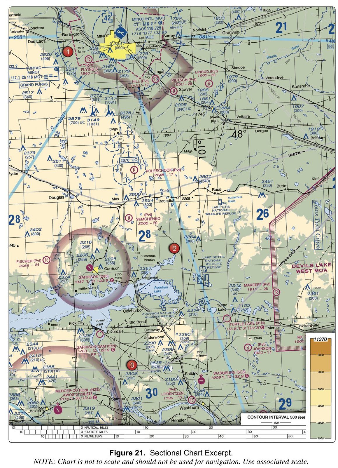
26. (Refer to FAA-CT-8080-2H, Figure 21.) What is the CTAF for Minot Intl (MOT)?
Figure 21 — Sectional chartOpen reference image
From the FAA testing supplement (FAA-CT-8080-2H). Tap the image to open it full size.
Why: In the Minot Intl (MOT) data block, 'CT - 118.2' is the control tower frequency. The star means the tower operates part-time, and the C in a circle after it means 118.2 is also the CTAF when the tower is closed. 118.725 is the ASOS weather frequency on the next line. 122.9 is the CTAF at other airports on the chart, such as Garrison Dam and Washburn.
27. (Refer to FAA-CT-8080-2H, Figure 59.) What is the common traffic advisory frequency (CTAF) for Lenawee County Airport (ADG)?
Figure 59 — Sectional chartOpen reference image
From the FAA testing supplement (FAA-CT-8080-2H). Tap the image to open it full size.
Why: On the chart, the airport symbol for Lenawee County (ADG) has the frequency 122.8 printed beside it as its CTAF. The value 122.9 is the CTAF for several nearby airports including Gradolph (88G), Bordner (3D8), Deshler (6D7), and Wyandot County (56D), and 123.0 is the CTAF for Fulton County (USE) and Ruhes (R47).
28. On a US sectional chart, how is Class D airspace depicted?
Why: Class D airspace is depicted with a dashed blue line on US sectional charts. The solid blue line option is wrong because that is the depiction for Class B airspace. The dashed magenta line option is wrong because that is the depiction for Class E airspace extending to the surface. Distinguishing these line styles and colors is essential for identifying which airspace class surrounds a given airport and what authorization or operating rules apply.
29. Before a flight, a remote pilot finds a temporary flight restriction (TFR) covering the planned operating area. Which statement is correct?
Why: Section 107.47 requires small UAS operations to comply with the flight restrictions designated by NOTAM under sections 91.137 through 91.145 and 99.7. A TFR applies to drones as much as to manned aircraft, and an airspace authorization does not override it. Check NOTAMs and TFRs before every flight.
30. A remote pilot intends to operate a small UAS within Class D airspace. What must the remote pilot do before beginning the operation?
Why: Class D is controlled airspace, and Part 107 requires ATC authorization before you fly there. Drone pilots get it through LAANC, which gives near-real-time approval at participating airports, or by applying through FAA DroneZone; you do not call the tower to get it. A flight plan is not part of the process, and a waiver is not needed because authorization, not a waiver, is what airspace access requires.
31. For an ordinary Part 107 operation in Class C airspace, without a specific airspace waiver, what must the remote pilot in command obtain before the flight?
Why: Obtain prior ATC authorization, commonly through an approved LAANC service or FAA DroneZone. Filing a flight plan does not provide that authorization, and airport management cannot grant it. An operational waiver does not automatically authorize controlled-airspace access; specific airspace waivers also exist. The ordinary authorization requirement applies in Class B, C, and D airspace and within the lateral boundaries of a Class E surface area designated for an airport.
32. A remote pilot intends to operate a small unmanned aircraft in Class E airspace that has a floor at 700 feet AGL. Which of the following is true?
Why: The Class E authorization requirement applies within the lateral boundaries of a Class E surface area designated for an airport. Class E beginning at 700 or 1,200 feet AGL does not itself trigger that requirement. Surface-level Class E extensions that are not airport-designated surface areas also do not trigger it. Check the actual airspace classification and any other flight restrictions.
33. On a US sectional chart, how is Class E airspace that extends to the surface depicted?
Why: Class E airspace extending to the surface is depicted with a dashed magenta line on US sectional charts. The shaded magenta band option is wrong because that depiction is used for Class E airspace with a floor at 700 feet AGL. The dashed blue line option is wrong because that is the depiction for Class D airspace. Recognizing the difference between the dashed magenta line (Class E to surface) and the shaded magenta band (Class E with a 700 ft floor) is important because the surface area of Class E at an airport requires prior authorization just like Class B, C, or D.