⚙ Test optionslength, one at a time or all, study mode
Length10 · 25 · all 33✓ Progress saved on this device
Airspace
1. A remote pilot plans to fly inside the actual three-dimensional volume of Class C airspace at a local airport. Which statement correctly describes the authorization requirement?
Why: For an ordinary Part 107 operation inside Class C airspace, the remote pilot must obtain prior ATC authorization through LAANC or FAA DroneZone. A position merely beneath a Class C shelf may be outside the Class C volume; pilots must use the sectional chart to identify the actual lateral and vertical boundaries. An authorization ceiling applies to the area and altitude specified in the authorization.
2. Which of the following airspace classes does NOT require an ATC airspace authorization for a remote pilot to operate a small unmanned aircraft?
Why: Prior ATC authorization is required in Class B, C and D airspace and within the lateral boundaries of the Class E surface area designated for an airport. Class G is uncontrolled and does not itself trigger this airspace-authorization requirement; other flight restrictions still apply. Not every surface-level Class E extension is an airport-designated surface area.
3. Which airspace class generally extends from 18,000 feet MSL up to and including flight level 600 over the contiguous United States?
Why: This is the general vertical range of Class A airspace. Class B has individually defined boundaries around busy airports. Class E includes several different types of controlled airspace, including airspace above flight level 600. This airspace-classification question does not authorize a Part 107 drone flight at these altitudes.
4. The Maximum Elevation Figure in a quadrangle on a sectional chart shows a large "3" followed by a smaller "5." What altitude does this represent?
Why: Maximum Elevation Figures (MEFs) are expressed in thousands and hundreds of feet MSL, so a large 3 followed by a smaller 5 represents 3,500 feet MSL. An MEF is a conservative maximum elevation for the quadrangle based on terrain and vertical obstacles: the FAA applies source-data error allowances and rounds up to the next 100 feet, so it is not simply the exact elevation of the single highest object.
5. A remote pilot plans to operate a small unmanned aircraft within the lateral boundaries of the Class B airspace core area at a large airport, where the airspace extends from the surface. What must the remote pilot obtain before the flight?
Why: Class B airspace, including its core area that extends from the surface, is controlled airspace. Part 107 requires prior ATC authorization before operating within Class B airspace, typically obtained through LAANC or the FAA's drone zone system. The "waiver" option is incorrect because a waiver is not needed for a standard controlled airspace operation; the pilot simply needs the standard airspace authorization. The "no additional authorization" option is wrong because Class B is controlled airspace and the standard Part 107 operating limits alone do not permit entry without prior authorization.
6. A remote pilot intends to operate a small UAS within Class D airspace. What must the remote pilot do before beginning the operation?
Why: Class D is controlled airspace, and Part 107 requires ATC authorization before you fly there. Drone pilots get it through LAANC, which gives near-real-time approval at participating airports, or by applying through FAA DroneZone; you do not call the tower to get it. A flight plan is not part of the process, and a waiver is not needed because authorization, not a waiver, is what airspace access requires.
7. Class B airspace around a large airport typically extends from the surface up to what altitude?
Why: Class B airspace typically tops out around 10,000 feet MSL, but the real figure is printed on the sectional chart for each airport and varies. 2,500 feet above the airport is the usual top of Class D, and 12,500 feet is not a standard airspace boundary. For a drone flight, read the chart rather than relying on a typical value.
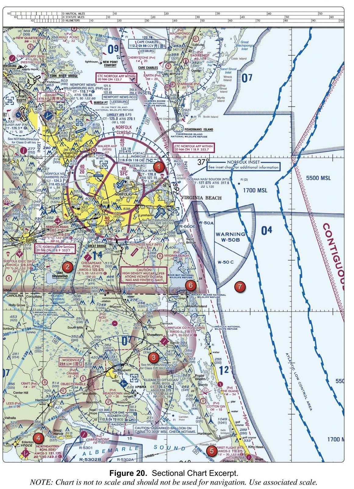
8. (Refer to FAA-CT-8080-2H, Figure 20.) What is the tower frequency for Newport News/Williamsburg International (PHF)?
Figure 20 — Sectional chartOpen reference image
From the FAA testing supplement (FAA-CT-8080-2H). Tap the image to open it full size.
Why: In the airport data block for Newport News/Williamsburg Intl (PHF), 'CT - 118.7' is the control tower frequency. 128.65 is the ATIS frequency printed on the line below it, and 118.425 is the ATIS frequency for Norfolk NS (Chambers), a different airport on the chart.
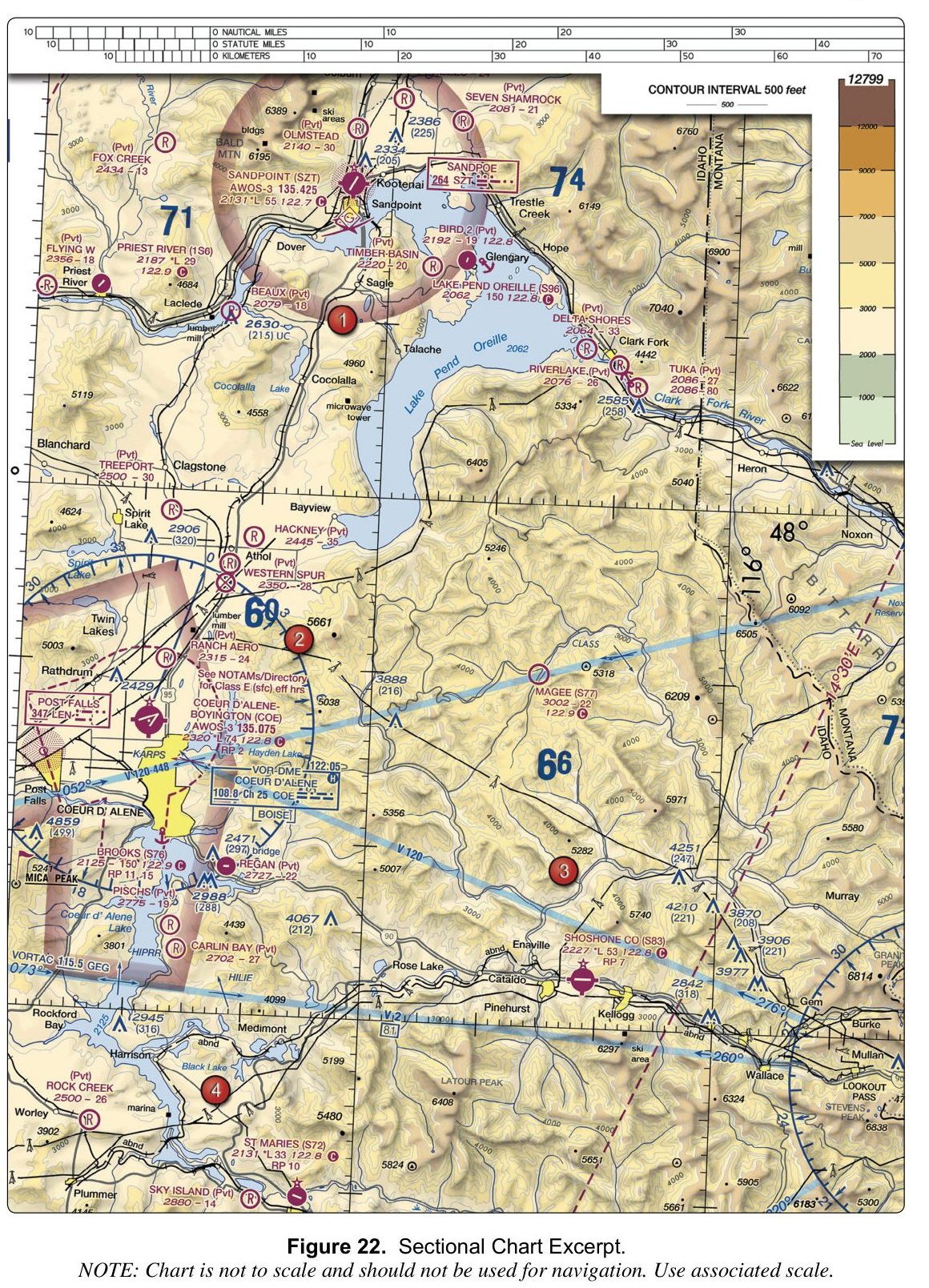
9. (Refer to FAA-CT-8080-2H, Figure 22.) The data block for Lake Pend Oreille (S96) shows a longest runway of 150. How long is the landing area?
Figure 22 — Sectional chartOpen reference image
From the FAA testing supplement (FAA-CT-8080-2H). Tap the image to open it full size.
Why: Lengths in a data block are printed in hundreds of feet, so 150 means 15,000 feet, not 1,500. The 5,300-foot figure belongs to Shoshone County (S83), printed as 53.
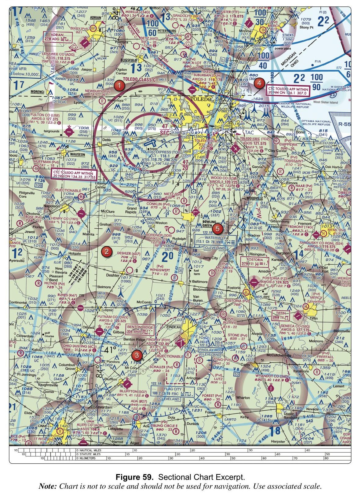
10. (Refer to FAA-CT-8080-2H, Figure 59.) What is the common traffic advisory frequency (CTAF) for Lenawee County Airport (ADG)?
Figure 59 — Sectional chartOpen reference image
From the FAA testing supplement (FAA-CT-8080-2H). Tap the image to open it full size.
Why: On the chart, the airport symbol for Lenawee County (ADG) has the frequency 122.8 printed beside it as its CTAF. The value 122.9 is the CTAF for several nearby airports including Gradolph (88G), Bordner (3D8), Deshler (6D7), and Wyandot County (56D), and 123.0 is the CTAF for Fulton County (USE) and Ruhes (R47).