⚙ Test optionslength, one at a time or all, study mode
Length10 · 25 · 50 · all 161✓ Progress saved on this device
Regulations
1. A client asks a remote pilot to carry a container of hazardous material with a small UAS. Under Part 107, which statement is correct?
Why: Section 107.36 prohibits a small unmanned aircraft from carrying hazardous material. It is not on the list of waivable rules in section 107.205, so an ordinary Part 107 waiver cannot authorize it; relief would require an exemption under 14 CFR part 11. Packaging the material to DOT standards does not change the prohibition.
2. A remote pilot is operating a drone fitted with a Remote ID broadcast module. What requirement applies to this pilot during the flight?
Why: A drone using a Remote ID broadcast module is limited to visual-line-of-sight operations: the Remote ID rule requires the person manipulating the flight controls to be able to see the aircraft at all times throughout the operation (14 CFR 89.115(a)(2)(ii)). This is a condition of the broadcast-module method itself, separate from the general Part 107 visual-line-of-sight rule. A broadcast module transmits the drone's identification and location and its take-off location; Standard Remote ID transmits the control-station location instead.
3. A pilot is landing on runway 32. What is the reciprocal runway designation for the opposite end of the same physical runway?
Why: Opposite ends of the same runway are reciprocals of each other, and their designations differ by exactly 18 (representing 180 degrees). Subtracting 18 from 32 gives 14, so the opposite end is runway 14. The 08 option would require a difference of 24, and the 20 option would require a difference of 12; neither represents a true reciprocal pair.
4. A small unmanned aircraft registration issued through FAA DroneZone under Part 48 is normally valid for:
Why: Registration under Part 48 is valid for 3 years unless it ends earlier under the applicable rules. Renew it before expiration to keep operating an aircraft that requires registration. This question concerns Part 48 registration through DroneZone, not the separate Part 47 aircraft-registration system.
5. For a drone subject to Remote ID requirements, with no Remote ID equipment and no separate FAA authorization to deviate, where may it be flown?
Why: A drone that must meet Remote ID but has no Remote ID equipment may fly only inside a FRIA, with the aircraft and the person manipulating the controls inside the FRIA and the aircraft within visual line of sight. There is no exception for private property or for uncontrolled (Class G) airspace. Drones not subject to registration or Remote ID requirements, and separately authorized operations, are outside this question.
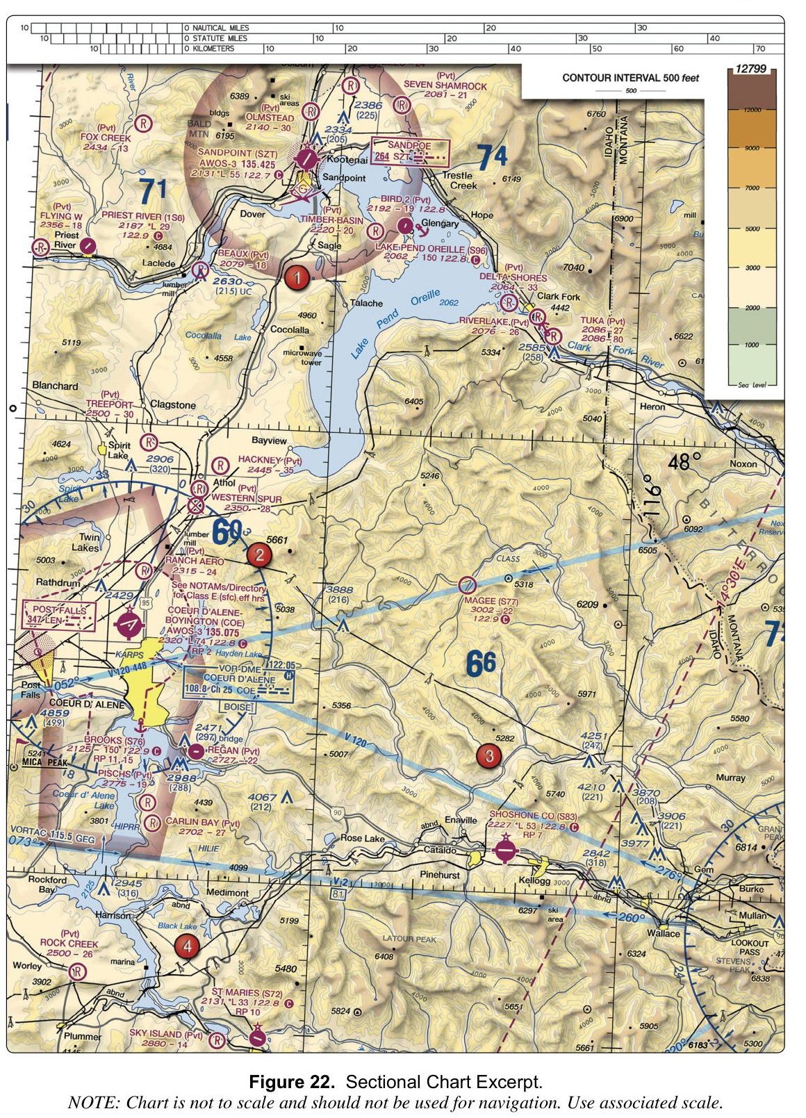
6. (Refer to FAA-CT-8080-2H, Figure 22.) What is the CTAF frequency for Priest River (1S6)?
Figure 22 — Sectional chartOpen reference image
From the FAA testing supplement (FAA-CT-8080-2H). Tap the image to open it full size.
Why: On the chart, the Priest River (1S6) airport entry lists its CTAF as 122.9, printed directly beside the airport identifier. The value 122.8 is the CTAF for several other airports on the same chart (Lake Pend Oreille, Coeur d'Alene-Boyington, Shoshone Co, St Maries), and 122.7 is the CTAF for Sandpoint (SZT). Read the frequency printed next to the 1S6 identifier to confirm 122.9.
7. The IMSAFE mnemonic used by remote pilots to evaluate personal fitness for flight stands for:
Why: The IMSAFE checklist covers Illness, Medication, Stress, Alcohol, Fatigue, and Emotion (some FAA publications also include Eating). The 'sleep' option is wrong because IMSAFE addresses fatigue as a broad condition, not specifically sleep deprivation as a separate item. The 'injuries' option is wrong because the mnemonic uses 'Illness,' which encompasses both acute and chronic health conditions but is the specific word in the acronym.
8. A METAR includes the wind group 32015G22KT. What does it report?
Why: In a METAR the first three digits are the direction the wind is blowing from, in degrees true; the next two are the sustained speed in knots; G introduces the gust speed. 32015G22KT is from 320 degrees true at 15 knots, gusting 22 knots.
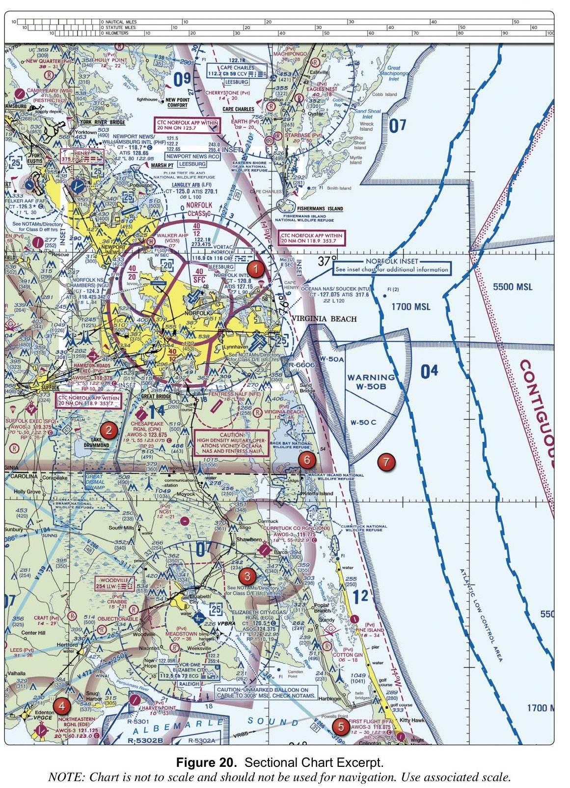
9. (Refer to FAA-CT-8080-2H, Figure 20.) What is the tower frequency for Newport News/Williamsburg International (PHF)?
Figure 20 — Sectional chartOpen reference image
From the FAA testing supplement (FAA-CT-8080-2H). Tap the image to open it full size.
Why: In the airport data block for Newport News/Williamsburg Intl (PHF), 'CT - 118.7' is the control tower frequency. 128.65 is the ATIS frequency printed on the line below it, and 118.425 is the ATIS frequency for Norfolk NS (Chambers), a different airport on the chart.
10. A recreational flyer owns a drone that weighs 200 grams and flies it exclusively for recreation. The flyer voluntarily registers the drone with the FAA. Which statement about Remote ID is correct?
Why: The FAA's published Remote ID guidance states that drones which are required to be registered or are registered, including those flown for recreation, business, or public safety, must comply with the Remote ID rule. Although a sub-250-gram recreational drone is not required to be registered, once the flyer voluntarily registers it, the drone falls under the Remote ID requirement. The rule is triggered by registration status, not by the type of pilot certificate held, so the option tying compliance to a Part 107 certificate is incorrect.
11. An international or U.S. military TAF contains the group: BECMG 1818/1820 5SM BR. What does this group indicate?
Why: BECMG means becoming. It indicates that a change in prevailing conditions is expected to occur at an unspecified time during the stated change period. The group 1818/1820 means from 1800 UTC to 2000 UTC on the 18th. By the end of the BECMG period, the new conditions (in this case 5 statute miles visibility with mist) are expected to have become prevailing unless another forecast group changes them. TEMPO is used for temporary fluctuations. An FM group is used when a new set of prevailing conditions begins at a specified time. Important U.S. note: civilian NWS TAFs do not use BECMG, although it may appear in international and U.S. military TAFs.
12. What is the difference in the location information broadcast by a Standard Remote ID drone versus a drone equipped with a Remote ID broadcast module?
Why: A Standard Remote ID drone is produced with built-in broadcast capabilities that provide identification and location information about the drone and the control station. A Remote ID broadcast module, by contrast, broadcasts identification and location information about the drone and its take-off location. This distinction matters operationally: the control station location is more dynamic (it updates as the pilot moves), while the take-off location is a fixed point established at the start of the flight.
13. A remote pilot's Category 3 drone has a category label that has become faded and partially illegible after prolonged sun exposure. What must the remote pilot do before conducting operations over human beings?
Why: If a Category 2 or Category 3 label is damaged, destroyed or missing, the remote pilot in command must relabel the aircraft in English, so that the label is legible, prominent and will remain on the aircraft for the duration of the operation, before flying over human beings. The label must correctly identify the category the aircraft is eligible for. There is no report to file with the FAA for a worn label, and removing it does not help: without a legible label the aircraft is not eligible for the operation, whether or not anyone inspects it.
14. What is the minimum visibility distance required for anti-collision lighting when operating a small unmanned aircraft at night under Part 107?
Why: Part 107 requires anti-collision lighting visible for at least 3 statute miles that has a flash rate sufficient to avoid a collision (14 CFR 107.29). One and two statute miles do not meet that minimum.
15. Under Part 107, how much time must pass after consuming an alcoholic beverage before a person may act as remote pilot in command, manipulate the flight controls, or serve as visual observer?
Why: Section 107.27 applies the alcohol and drug rules of section 91.17: no person may act as a crewmember within 8 hours after consuming any alcoholic beverage, while under the influence of alcohol, with a blood or breath alcohol concentration of 0.04 or greater, or while using any drug that affects their faculties in a way contrary to safety. Waiting 8 hours is necessary but not always enough: you must also no longer be under the influence.
16. A remote pilot certificate holder changes their permanent mailing address. Which statement correctly describes the FAA requirement?
Why: Under 14 CFR 107.77(c), a certificate holder who changes their permanent mailing address may not exercise the privileges of the certificate more than 30 days after the change unless the FAA has been notified, either by letter to the Airman Certification Branch or through the FAA web portal. The key point is that privileges stop after 30 days until the address is updated, not simply "written notification within 30 days." Any change of permanent mailing address counts, and no new certificate is required.
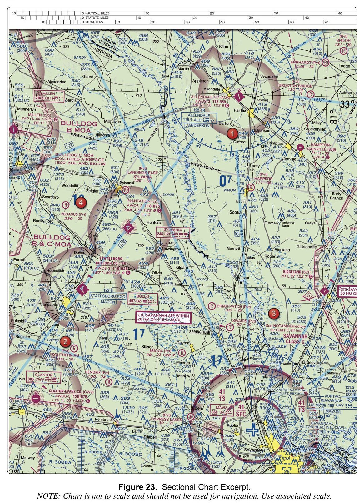
17. (Refer to FAA-CT-8080-2H, Figure 23.) The obstacle just east of area 1, near Gifford, has a height of:
Figure 23 — Sectional chartOpen reference image
From the FAA testing supplement (FAA-CT-8080-2H). Tap the image to open it full size.
Why: Next to area 1, beside Gifford, the obstacle is labelled 549 with (428) beneath it. The bold number is the height of the top above mean sea level; the number in parentheses is its height above ground level. So it is 549 feet MSL, or 428 feet above the ground.
18. A remote pilot intends to operate a small UAS within Class D airspace. What must the remote pilot do before beginning the operation?
Why: Class D is controlled airspace, and Part 107 requires ATC authorization before you fly there. Drone pilots get it through LAANC, which gives near-real-time approval at participating airports, or by applying through FAA DroneZone; you do not call the tower to get it. A flight plan is not part of the process, and a waiver is not needed because authorization, not a waiver, is what airspace access requires.
19. A UAS Facility Map shows a value of 350 feet AGL for a particular grid. What does that value indicate?
Why: UAS Facility Maps show altitudes that the FAA has determined can generally be authorized without additional safety analysis or facility coordination. The value does not itself permit flight in controlled airspace; the pilot must still obtain an airspace authorization, at any altitude. For Part 107 operations, a pilot may also submit a LAANC Further Coordination request to fly above the displayed altitude, up to 400 feet AGL, subject to FAA review. So 350 feet is neither a no-authorization altitude nor the highest altitude that can ever be approved.
20. During a Part 107 flight, the battery begins depleting much faster than expected and may not provide enough power to complete the planned flight. What is the best action?
Why: Abnormal battery depletion can lead to a loss of power, so sound aeronautical decision-making is to terminate the mission and land at a suitable spot as soon as practicable, away from people and property, rather than rely on an automatic return-to-home that may not complete. Climbing uses more power and adds risk. If the situation becomes an in-flight emergency, section 107.21 permits deviation from Part 107 to the extent necessary to address that emergency.
Source: FAA Remote Pilot Study Guide (FAA-G-8082-22), emergency procedures; 14 CFR 107.21
21. A remote pilot plans to operate a small unmanned aircraft at a distance where neither the remote pilot nor any visual observer can maintain continuous visual contact with the aircraft. What is required before conducting this operation?
Why: Keeping the aircraft within visual line of sight is one of the rules the FAA will waive, so an operation where neither the remote pilot nor a visual observer can see the aircraft needs a Part 107 waiver before it is flown. Remote ID is a separate requirement: broadcasting identification tells others who is flying, it does not relieve anyone of the duty to see the aircraft. LAANC gives airspace authorization to fly in controlled airspace near an airport, which is a different permission and says nothing about flying beyond visual line of sight.
22. A Standard Remote ID drone is best described as:
Why: A Standard Remote ID drone is one produced with built-in FAA Remote ID broadcast capabilities. The broadcast-module option is a separate compliance path used to retrofit a drone that lacks built-in capability, so the module-equipped drone is not itself a 'Standard Remote ID drone.' Registration is a separate requirement, for every drone flown under Part 107 and for recreational drones of 250 g or more, and displaying a registration number does not make a drone Remote ID compliant.
23. During operations under a Part 107 certificate of waiver, where must a copy of the waiver be kept?
Why: Operations under a waiver must meet the waiver's conditions, and its standard provisions require a copy of the certificate of waiver to be available to the remote pilot in command at the control station during covered operations. Nothing is filed with the FSDO before each flight, and the waiver is not displayed on the aircraft. Always follow the specific document requirements in your own waiver.
24. A remote pilot holds a Part 107 waiver for operations over people and wants to fly without broadcasting Remote ID. Which statement is correct?
Why: A Part 107 waiver covers only the Part 107 sections listed in 107.205. Remote ID is a separate rule: no person may operate without meeting the Remote ID requirements except as otherwise authorized by the Administrator or in an FAA-recognized identification area (14 CFR 89.105). The FAA gives that authorization separately and only for limited purposes, such as aeronautical research, so holding a Part 107 waiver of any kind does not remove the Remote ID requirement.
25. (Refer to FAA-CT-8080-2H, Figure 20.) The data block for Langley AFB (LFI) shows a longest runway of 100. How long is the runway?
Figure 20 — Sectional chartOpen reference image
From the FAA testing supplement (FAA-CT-8080-2H). Tap the image to open it full size.
Why: Runway lengths in an airport data block are printed in hundreds of feet, so 100 means 10,000 feet. The 12,000-foot figure belongs to Oceana NAS (NTU), printed as 120, and the 6,000-foot figure to Northeastern Regional (EDE), printed as 60.